![[freedomtowernight_edited.jpg]](https://blogger.googleusercontent.com/img/b/R29vZ2xl/AVvXsEi-x7_mwi5EYyZJxpzNqsvkYATDseYTHIovP09YKrIctspB17DY_5s2AeackCCaZqX14NV-rcs5S81-anUoEkQcrbMqc9hATVpw0uU3hH1tyIbe0iq0Jfe5iTwGlJaoODZXAOt_Kg/s1600/freedomtowernight_edited.jpg)
Hurricane Rita (Updated)
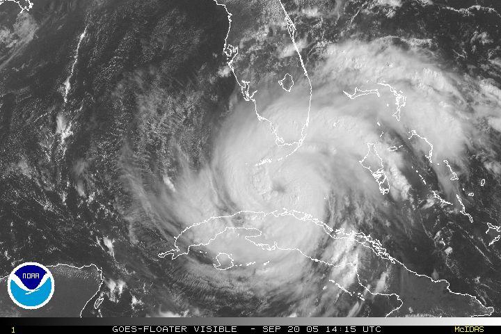
Photo courtesy of NOAA
As of this late AM hour, Hurricane Rita is passing south of Miami, between Cuba and the Florida Keys. A slightly more due west track than forecasted has taken South Florida mostly off the hook as far as the nastiest of the winds, although the weather here is far from being nice.
The main concern is the Keys, particularly Key West. It's going to be a VERY close call as to whether they will get the strongest winds (up to 85 mph as of right now). There's a chance those winds could barely miss Key West, and that's what we hope for.
Many of us here on the mainland, including your favorite Cuban-American bloggers, put up shutters yesterday just in case. That's the way it usually works out...you put them up just for precautionary measures.
That's fine by me, I'd rather be safe than sorry. Let's hope the same applies for those who evacuated the Keys.
UPDATED 2:20 PM - Rita now has 100 mph winds and is a Category 2 hurricane. That's an increase of 25 mph in only 6 hours. It still looks like Key West is going to escape the worst of Rita as the eye wall passes just south of the city. Unless Rita makes an unexpected turn to the north (it's rapidly running out of time), Key Westers should consider themselves extremely lucky. Flooding will still be a big problem down there, but nothing like New Orleans.
The eye wall is also passing just north of Havana and Varadero, so Cuba should also escape serious damage, although the heavy rains affecting Havana could cause some of the many dilapidated buildings in Old Havana to collapse.
posted by Robert at 11:46 AM
![]()


0 Comments:
Post a Comment
<< Home